Apr 27, 2013

The World's Largest Bus

The world's largest bus that is 101ft long and can carry 256 passengers

    1) The Auto Tram Extra Grand is being trialed in Dresden, Germany
    2) It is the longest bus in the world at nearly 101ft long vehicle
    3) Beijing and Shanghai have placed orders for the bus
    4) It runs mostly on electric power
    5) The vehicle combines the capacity of a small train with the maneuverability of a bus


The big bendy bus premiered in the eastern city of Dresden this week where it will soon roll into service with the local transportation authority on trial runs as Beijing and Shanghai placed their orders for the vehicle which costs $1.25 million (almost £778,000) per bus. It combines the passenger capacity of a small train with the maneuverability of a bus and runs on a hybrid engine that kicks in when the electric batteries run down, charging them as it propels the vehicle.

Bus drivers will not require a special license to drive the long, bendy bus thanks to a unique computer steering system which keeps the length of the bus precisely in line with the front carriage. The system is less expensive to run and cheaper to put into operation than a rail commuter system, prompting other cities to inquire about the super-sized buses. Dr Klinger said: The Auto Tram has a considerable advantage compared to light rail systems. While it is the longest bus in the world, the bus with the largest capacity is China's New Liner Series which has 300 seats on a 82ft bus.

Apr 17, 2013

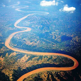
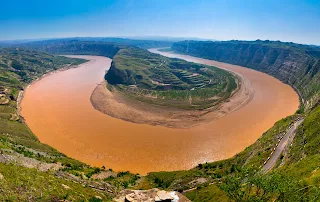
The Yellow River (The Cradle of Chinese Civilization), Bayan Har Mountains, Western China

The Yellow River or Huang He is the second-longest river in Asia, following the Yangtze River, and the sixth-longest river system in the world at the estimated length of 5,464 km (3,395 mi). Originating in the Bayan Har Mountains in Qinghai province of western China, it flows through nine provinces, and it empties into the Bohai Sea near the city of Dongying in Shandong province. The Yellow River basin has an east–west extent of about 1,900 kilometers (1,180 mi) and a north–south extent of about 1,100 km (680 mi). 
 
Its total basin area is about 742,443 square kilometers (286,659 sq mi). Its basin was the birthplace of ancient Chinese civilization, and it was the most prosperous region in early Chinese history. However, because of frequent devastating floods and course changes produced by the continual elevation of the river bed, sometimes above the level of its surrounding farm fields, it also has the names China's Sorrow and Scourge of the Sons of Han.


According to the China Exploration and Research Society, the source of the Yellow River is at 34° 29' 31.1" N, 96° 20' 24.6" E in the Bayan Har Mountains near the eastern edge of the Yushu Tibetan Autonomous Prefecture. The source tributuaries drain into Gyaring Lake and Ngoring Lake on the western edge of Golog Prefecture high in the Bayan Har Mountains of Qinghai. In the Zoige Basin along the boundary with Gansu, the Yellow River loops northwest and then northeast before turning south, creating the "Ordos Loop", and then flows generally eastward across the North China Plain to the Gulf of Bohai, draining a basin of 752,443 square kilometers (290,520 sq mi) which nourishes 140 million people with drinking water and irrigation.

The Yellow River passes through seven present-day provinces and two autonomous regions, namely (from west to east) Qinghai, Gansu, Ningxia, Inner Mongolia, Shaanxi, Shanxi, Henan, and Shandong. Major cities along the present course of the Yellow River include (from west to east) Lanzhou, Yinchuan, Wuhai, Baotou, Luoyang, Zhengzhou, Kaifeng, and Jinan. The current mouth of the Yellow River is located at Kenli County, Shandong. The river is commonly divided into three stages. These are roughly the northeast of the Tibetan Plateau, the Ordos Loop, and the North China Plain. However, different scholars have different opinions on how the three stages are divided.

The Yellow River is notable for the large amount of silt it carries—1.6 billion tons annually at the point where it descends from the Loess Plateau. If it is running to the sea with sufficient volume, 1.4 billion tons are carried to the sea annually.[citation needed] One estimate gives 34 kilograms of silt per cubic meter as opposed to 10 for the Colorado and 1 for the Nile.

Its average discharge is said to be 2,110 cubic meters per second (32,000 for the Yangtze), with a maximum of 25,000 and minimum of 245. However, since 1972, it often runs dry before it reaches the sea. The low volume is due to increased agricultural irrigation, increased by a factor of five since 1950. Water diverted from the river as of 1999 served 140 million people and irrigated 74,000 km² (48,572 mi²) of land. The Yellow River delta totals 8,000 square kilometers (3,090 mi²). However, with the decrease in silt reaching the sea, it has been reported to be shrinking slightly each year since 1996 through erosion.

The highest volume occurs during the rainy season from July to October, when 60% of the annual volume of the river flows. Maximum demand for irrigation is needed between March and June. In order to capture excess water for use when needed and for flood control and electricity generation, several dams have been built, but their expected life is limited due to the high silt load. A proposed South–North Water Transfer Project involves several schemes to divert water from the Yangtze River: one in the western headwaters of the rivers where they are closest to one another, another from the upper reaches of the Han River, and a third using the route of the old Grand Canal. Due to its heavy load of silt the Yellow River is a depositing stream – that is, it deposits part of its carried burden of soil in its bed in stretches where it is flowing slowly. These deposits elevate the riverbed which flows between natural levees in its lower reaches. Should a flood occur, the river may break out of the levees into the surrounding lower flood plain and take a new channel. Historically this has occurred about once every hundred years. In modern times, considerable effort has been made to strengthen levees and control floods 
For more details - Yellow_River

The Last Dragon (Frozen Ice Dragon) 2004

The Last Dragon, known as Dragons: A Fantasy Made Real in the United States, and also known as Dragon's World in other countries, is a British docufiction made by Darlow Smithson Productions for Channel Four and broadcast on both Channel Four and Animal Planet that is described as the story of "the natural history of the most extraordinary creature that never existed".

It posits a speculative evolution of dragons from the Cretaceous period up to the 15th century, and suppositions about what dragon life and behavior might have been like if they had existed and evolved. It uses the premise that the ubiquity of dragons in world mythology suggests that dragons could have existed. They are depicted as a scientifically feasible species of reptile that could have evolved, somewhat similar to the depiction of dragons in the Dragonology series of books. The dragons featured in the show were designed by John Sibbick.

The program switches between two stories. The first uses CGI to show the dragons in their natural habitat throughout history. The second shows the story of a modern-day scientist at a museum, Dr. Tanner, who believes in dragons. When the frozen remains of an unknown creature are discovered in the Carpathian Mountains, Tanner, and two colleagues from the museum, undertake the task to examine the specimen to try to save his reputation. Once there, they discover that the creature is a dragon. Tanner and his colleagues set about working out how it lived and died.

Also Known As:

The Last Dragon (UK / USA)
Dragon's World: A Fantasy Made Real USA (DVD title)
Dragons: A Fantasy Made Real USA
Magical productions aside, it may be a little letdown if you were hoping this was actually a real dragon. But personally...I think a real dragon would be less careless with leaving their fossilized remains behind on planet Earth, for us mortals to wander upon and "discover".

For More Details - The Last Dragon 2004

Niagara Falls (Wonder of Mother Natuer), Ontario, Canada

Niagara Falls is the collective name for three waterfalls that straddle the international border between Canada and the United States; more specifically, between the province of Ontario and the state of New York. They form the southern end of the Niagara Gorge.

From largest to smallest, the three waterfalls are the Horseshoe Falls, the American Falls and the Bridal Veil Falls. The Horseshoe Falls lies on the border of the United States and Canada with the American Falls entirely on the United States' side, separated by Goat Island. The smaller Bridal Veil Falls are also on the United States' side, separated from the other waterfalls by Luna Island. The international boundary line was originally drawn through Horseshoe Falls in 1819, but the boundary has long been in dispute due to natural erosion and construction.

Located on the Niagara River, which drains Lake Erie into Lake Ontario, the combined falls form the highest flow rate of any waterfall in the world that has a vertical drop of more than 165 feet (50 m). Horseshoe Falls is the most powerful waterfall in North America, as measured by flow rate. The falls are 17 miles (27 km) north-northwest of Buffalo, New York, and 75 miles (121 km) south-southeast of Toronto, between the twin cities of Niagara Falls, Ontario, and Niagara Falls, New York.

Niagara Falls was formed when glaciers receded at the end of the Wisconsin glaciation (the last ice age), and water from the newly formed Great Lakes carved a path through the Niagara Escarpment en route to the Atlantic Ocean. While not exceptionally high, Niagara Falls is very wide. More than six million cubic feet (168,000 m3) of water falls over the crest line every minute in high flow,and almost four million cubic feet (110,000 m3) on average.

Niagara Falls is famed both for its beauty and as a valuable source of hydroelectric power. Balancing recreational, commercial, and industrial uses has been a challenge for the stewards of the falls since the 19th century.


The Horseshoe Falls drop about 188 feet (57 m), while the height of the American Falls varies between 70 and 100 feet (21 and 30 m) because of the presence of giant boulders at its base. The larger Horseshoe Falls are about 2,600 feet (790 m) wide, while the American Falls are 1,060 feet (320 m) wide. The distance between the American extremity of the Niagara Falls and the Canadian extremity is 3,409 feet (1,039 m).

The volume of water approaching the falls during peak flow season may sometimes be as much as 225,000 cubic feet (6,400 m3) per second. The average annual flow rate is 85,000 cubic feet (2,400 m3) per second. Since the flow is a direct function of the Lake Erie water elevation, it typically peaks in late spring or early summer. During the summer months, at least 100,000 cubic feet (2,800 m3) per second of water traverses the falls, some 90% of which goes over the Horseshoe Falls, while the balance is diverted to hydroelectric facilities. This is accomplished by employing a weir the International Control Dam with movable gates upstream from the Horseshoe Falls. The falls' flow is further halved at night, and, during the low tourist season in the winter, remains a minimum of 50,000 cubic feet (1,400 m3) per second. Water diversion is regulated by the 1950 Niagara Treaty and is administered by the International Niagara Board of Control. The verdant green color of the water flowing over the Niagara Falls is a byproduct of the estimated 60 tonnes/minute of dissolved salts and "rock flour" (very finely ground rock) generated by the erosive force of the Niagara River itself. The current rate of erosion is approximately 1 foot (0.30 m) per year, down from a historical average of 3 feet (0.91 m) per year. It is estimated that 50,000 years from now, even at this reduced rate of erosion, the remaining 20 miles (32 km) to Lake Erie will have been undermined and the falls will cease to exist
 
For the more details - Niagara Falls   

Apr 12, 2013

Genghis Khan Equestrian Statue (Biggest Equestrian Statue In The World), Erdene, Töv Province, Mongolia

The Genghis Khan Equestrian Statue is dedicated to founder of the Mongol Empire, which became the largest contiguous empire in history after his death. Genghis Khan Statue Complex is a 40 metre (131 ft 3 in) tall statue of Genghis Khan on horseback, on the bank of the Tuul River at Tsonjin Boldog (54 km (33.55 mi) east of the Mongolian capital Ulan Bator), where according to legend, he found a golden whip. The statue is symbolically pointed east towards his birthplace. It is on top of the Genghis Khan Statue Complex, a visitor center, itself 10 meters (32 ft 10 in) tall, with 36 columns representing the 36 khans from Genghis to Ligdan Khan. It was designed by sculptor D. Erdenebileg and architect J. Enkhjargal and erected in 2008.
 
Genghis Khan (c. 1162 – August 18, 1227), He came to power by uniting many of the nomadic tribes of Northeast Asia. After founding the Empire and being proclaimed "Genghis Khan", he launched the Mongol invasions that conquered most of Eurasia. Campaigns initiated in his lifetime include those against the Qara Khitai, Caucasus, and Khwarazmian, Western Xia and Jin dynasties. These campaigns were often accompanied by large-scale massacres of the civilian populations – especially in the Khwarazmian and Western Xia controlled lands. By the end of his life, the Mongol Empire occupied a substantial portion of Central Asia and China.

Before Genghis Khan died he assigned Ögedei Khan as his successor. Later his grandsons split his empire into khanates. He died in 1227 after defeating the Western Xia. He was buried in an unmarked grave somewhere in Mongolia. His descendants extended the Mongol Empire across most of Eurasia by conquering or creating vassal states in all of modern-day China, Korea, the Caucasus, Central Asia, and substantial portions of Eastern Europe and Southwest Asia. Many of these invasions repeated the earlier large-scale slaughters of local populations. As a result, Genghis Khan and his empire have a fearsome reputation in local histories.

Beyond his military accomplishments, Genghis Khan also advanced the Mongol Empire in other ways. He decreed the adoption of the Uyghur script as the Mongol Empire's writing system. He also practiced meritocracy and encouraged religious tolerance in the Mongol Empire, and unified the nomadic tribes of Northeast Asia. Present-day Mongolians regard him as the founding father of Mongolia.Although known for the brutality of his campaigns and considered by many to have been a genocidal ruler, Genghis Khan is also credited with bringing the Silk Road under one cohesive political environment. This brought communication and trade from Northeast Asia into Muslim Southwest Asia and Christian Europe, thus expanding the horizons of all three cultural areas.


Visitors walk to the head of the horse through its chest and neck, where they have a panoramic view. The main statue area will be surrounded by 200 ger (yurts), designed and arranged like the pattern of the horse brand marks that were used by the 13th century Mongol tribes. The cost of the complex is reported to be US$4.1 million, spent by The Genco Tour Bureau, a Mongolian company.

The attached museum has exhibitions relating to the Bronze Age and Xiongnu archaeological cultures in Mongolia, which show everyday utensils, belt buckles, knives, sacred animals, etc. and a second exhibition on the Great Khan period in the 13 and 14th centuries which has ancient tools, goldsmith subjects and some Nestorian crosses and rosaries. Adjacent to the museum is a tourist and recreation center, which covers 212 hectares (520 acres).
 
Inside the two-story base of the statue, visitors can see a replica of Genghis Khan’s legendary golden whip, sample traditional cuisine of horse meat and potatoes, or play billiards. Visitors can ascend to the exhibition hall using an elevator at the back of the horse and then walk to the horse’s head passing through its chest and the back of its neck from where they can have an excellent panoramic view over the complex area and the scenery beyond.

The Chinggis Khan Statue is currently the biggest equestrian statue in the world.

For More Details-