Jan 31, 2013

Pompeii (The Stone People), Province of Naples, Campania, Italy

Pompeii was an ancient Roman town-city near modern Naples, in the Campania region of Italy, in the territory of the comune of Pompei. Pompeii, along with Herculaneum and many villas in the surrounding area, was mostly destroyed and buried under 4 to 6 m (13 to 20 ft) of volcanic ash and pumice in the eruption of Mount Vesuvius in 79 AD.

Researchers believe that the town was founded in the seventh or sixth century BC by the Osci or Oscans. It came under the domination of Rome in the 4th century BC, and was conquered and became a Roman colony in 80 BC after it joined an unsuccessful rebellion against the Roman Republic. By the time of its destruction, 160 years later, its population was estimated at 11,000 people, and the city had a complex water system, an amphitheater, gymnasium, and a port.

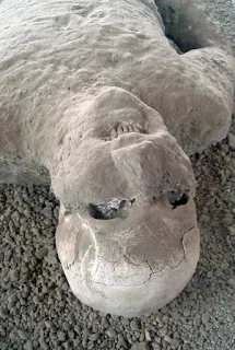
The eruption destroyed the city, killing its inhabitants and burying it under tons of ash. Evidence for the destruction originally came from a surviving letter by Pliny the Younger, who saw the eruption from a distance and described the death of his uncle Pliny the Elder, an admiral of the Roman fleet, who tried to rescue citizens. The site was lost for about 1,500 years until its initial rediscovery in 1599 and broader rediscovery almost 150 years later by Spanish engineer Rocque Joaquin de Alcubierre in 1748. The objects that lay beneath the city have been preserved for more than a millennium because of the lack of air and moisture. These artifacts provide an extraordinarily detailed insight into the life of a city during the Pax Romana. During the excavation, plaster was used to fill in the voids in the ash layers that once held human bodies. This allowed archaeologists to see the exact position the person was in when he or she died. Pompeii has been a tourist destination for over 250 years. Today it has UNESCO World Heritage Site status and is one of the most popular tourist attractions in Italy, with approximately 2.5 million visitors every year.


After thick layers of ash covered Pompeii and Herculaneum, they were abandoned and eventually their names and locations were forgotten. The first time any part of them was unearthed was in 1599, when the digging of an underground channel to divert the river Sarno ran into ancient walls covered with paintings and inscriptions. The architect Domenico Fontana was called in; he unearthed a few more frescoes, then covered them over again, and nothing more came of the discovery. A wall inscription had mentioned a decurio Pompeii ("the town Councillor of Pompeii") but its reference to the long-forgotten Roman city was missed.

Fontana's covering over the paintings has been seen both as a broad-minded act of preservation for later times, and as censorship in view of the frequent sexual content of such paintings, as he would have known that paintings of the hedonistic kind later found in some Pompeian villas were not considered in good taste in the climate of the counter-reformation.

Herculaneum was properly rediscovered in 1738 by workmen digging for the foundations of a summer palace for the King of Naples, Charles of Bourbon. Pompeii was rediscovered as the result of intentional excavations in 1748 by the Spanish military engineer Rocque Joaquin de Alcubierre. These towns have since been excavated to reveal many intact buildings and wall paintings. Charles of Bourbon took great interest in the findings even after becoming king of Spain because the display of antiquities reinforced the political and cultural power of Naples.

Karl Weber directed the first real excavations; he was followed in 1764 by military engineer Franscisco la Vega. Franscisco la Vega was succeeded by his brother, Pietro, in 1804. During the French occupation Pietro worked with Christophe Saliceti.

Giuseppe Fiorelli took charge of the excavations in 1863. During early excavations of the site, occasional voids in the ash layer had been found that contained human remains. It was Fiorelli who realized these were spaces left by the decomposed bodies and so devised the technique of injecting plaster into them to recreate the forms of Vesuvius's victims. This technique is still in use today, with a clear resin now used instead of plaster because it is more durable, and does not destroy the bones, allowing further analysis.

The discovery of erotic art in Pompeii and Herculaneum left the archaeologists with a dilemma – between the mores of sexuality in ancient Rome and in Counter-Reformation Europe lay a clash of cultures. An unknown number of discoveries were hidden away again. A wall fresco depicting Priapus, the ancient god of sex and fertility, with his extremely enlarged penis, was covered with plaster. An older reproduction was locked away "out of prudishness" and opened only on request—and only rediscovered in 1998 due to rainfall.

A large number of artifacts from the buried cities are preserved in the Naples National Archaeological Museum. In 1819, when King Francis visited the Pompeii exhibition there with his wife and daughter, he was so embarrassed by the erotic artwork that he decided to have it locked away in a so-called "secret cabinet" (gabinetto segreto), a gallery within the museum accessible only to "people of mature age and respected morals". Re-opened, closed, re-opened again and then closed again for nearly 100 years, the Naples "Secret Museum" was briefly made accessible again at the end of the 1960s (the time of the sexual revolution) and was finally re-opened for viewing in 2000. Minors are still allowed entry only in the presence of a guardian or with written permission.

Pompeii has been a popular tourist destination for over 250 years; it was on the Grand Tour. By 2008, it was attracting almost 2.6 million visitors per year, making it one of the most popular tourist sites in Italy. It is part of a larger Vesuvius National Park and was declared a World Heritage Site by UNESCO in 1997. To combat problems associated with tourism, the governing body for Pompeii, the Soprintendenza Archaeological di Pompei have begun issuing new tickets that allow for tourists to also visit cities such as Herculaneum and Stabiae as well as the Villa Poppaea, to encourage visitors to see these sites and reduce pressure on Pompeii.

Pompeii is also a driving force behind the economy of the nearby town of Pompei. Many residents are employed in the tourism and hospitality business, serving as taxi or bus drivers, waiters or hotel operators. The ruins can be easily reached on foot from the Circumvesuviana train stop called Pompei Scavi, directly at the ancient site. There are also car parks nearby.

Excavations in the site have generally ceased due to the moratorium imposed by the superintendent of the site, Professor Pietro Giovanni Guzzo. Additionally, the site is generally less accessible to tourists, with less than a third of all buildings open in the 1960s being available for public viewing today. Nevertheless, the sections of the ancient city open to the public are extensive, and tourists can spend several days exploring the whole site.
For more details - Pompeii

Church Of Bones, Kutná Hora, Czech Republic

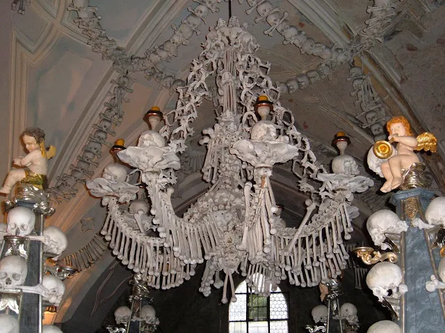
The Sedlec Ossuary is a small Roman Catholic chapel, located beneath the Cemetery Church of All Saints in Sedlec, a suburb of Kutná Hora in the Czech Republic. The ossuary is estimated to contain the skeletons of between 40,000 and 70,000 people, whose bones have in many cases been artistically arranged to form decorations and furnishings for the chapel. The ossuary is among the most visited tourist attractions of the Czech Republic, attracting over 200,000 visitors yearly.  

Four enormous bell-shaped mounds occupy the corners of the chapel. An enormous chandelier of bones, which contains at least one of every bone in the human body, hangs from the center of the nave with garlands of skulls draping the vault. Other works include piers and monstrances flanking the altar, a large Schwarzenberg coat of arms, and the signature of Rint, also executed in bone, on the wall near the entrance.


In 1278, Henry, the abbot of the Cistercian monastery in Sedlec, was sent to the Holy Land by King Otakar II of Bohemia. He returned with him a small amount of earth he had removed from Golgotha and sprinkled it over the abbey cemetery. The word of this pious act soon spread and the cemetery in Sedlec became a desirable burial site throughout Central Europe.

In the mid 14th century, during the Black Death, and after the Hussite Wars in the early 15th century, many thousands were buried in the abbey cemetery, so it had to be greatly enlarged and around 1400, a Gothic church was built in the center of the cemetery with a vaulted upper level and a lower chapel to be used as an ossuary for the mass graves unearthed during construction, or simply slated for demolition to make room for new burials.

After 1511, the task of exhuming skeletons and stacking their bones in the chapel was given to a half-blind monk of the order. Between 1703 and 1710, a new entrance was constructed to support the front wall, which was leaning outward, and the upper chapel was rebuilt. This work, in the Czech Baroque style, was designed by Jan Santini Aichel.

In 1870, František Rint, a woodcarver, was employed by the Schwarzenberg family to put the bone heaps into order, yielding a macabre result. The signature of Rint, also executed in bone, appears on the wall near the entrance to the chapel.
 
For more details - Official Website

Jan 30, 2013

Cave of the Crystals,Chihuahua, Mexico

Cave of the Crystals or Giant Crystal Cave (Spanish: Cueva de los Cristales) is a cave connected to the Naica Mine 300 metres (980 ft) below the surface in Naica, Chihuahua, Mexico.

The main chamber contains giant selenite crystals (gypsum, CaSO4·2 H2O), some of the largest natural crystals ever found. The cave's largest crystal found to date is 12 m (39 ft) in length, 4 m (13 ft) in diameter and 55 tons in weight. The cave is extremely hot, with air temperatures reaching up to 58 °C (136 °F) with 90 to 99 percent humidity. The cave is relatively unexplored due to these factors. Without proper protection, people can only endure approximately ten minutes of exposure at a time.

A group of scientists known as the Naica Project have been heavily involved in researching these caverns

Naica lies on an ancient fault above an underground magma chamber below the cave. The magma heated the ground water which was saturated with sulfide ions (S2−). Cool oxygenated surface water contacted the mineral saturated heated water, but the two did not mix due to the difference in their densities. The oxygen slowly diffused into the heated water and oxidized the sulfides (S2−) into sulfates (SO42−). The hydrated sulfate gypsum crystallized at an extremely slow rate over the course of at least 500,000 years, forming the enormous crystals found today. The key to this process is the slow diffusion of oxygen from the cool, low density surface water into the hot, high density ground water


The cave was discovered by the brothers Eloy and Javier Delgado. In 1910 miners discovered a cavern beneath the Naica mine workings, the Cave of Swords (Spanish: Cueva de las Espadas). It is located at a depth of 120 m, above the Cave of Crystals, and contains spectacular, smaller (1 m long) crystals. It is speculated that at this level, transition temperatures may have fallen much more rapidly, leading to an end in the growth of the crystals.The Giant Crystal cave was discovered in 2000 by miners excavating a new tunnel for the Industrias Peñoles mining company located in Naica, Mexico, while drilling through the Naica fault, which they were concerned would flood the mine.The mining complex in Naica contains substantial deposits of silver, zinc and lead.

Two other smaller caverns were also discovered in 2000, Queen’s Eye Cave and Candles Cave, and a further chamber was found in a drilling project in 2009. The new cave, named Ice Palace, is 150 m deep and is not flooded, but its crystal formations are much smaller, with small "cauliflower" formations and fine, threadlike crystals.

All of the caves discovered currently are: Cave of Crystals, Queen's Eye, Candles Cave, Ice Palace and Cave of Swords.

For more detailsCave of the Crystals

Waitomo Glowworm Caves, North Island, New Zealand

The Waitomo Glowworm Caves attraction is a cave at Waitomo on the North Island of New Zealand. It is known for its population of Arachnocampa luminosa, a glowworm species found exclusively in New Zealand. This cave is part of the Waitomo Caves system that includes the Ruakuri Cave and the Aranui Cave.

The Waitomo Glowworm Caves were first explored in 1887 by local Maori Chief Tane Tinorau accompanied by an English surveyor Fred Mace. Local Maori people knew of the Caves existence, but the subterranean caverns had never been extensively explored until Fred and Tane went to investigate. They built a raft of flax stems and with candles as their only lighting, floated into the cave where the stream goes underground.

Geological and volcanic activity has created around 300 known limestone caves in the Waitomo region over the last 30 million years. The limestone formation in the Waitomo Glowworm Caves occurred when the region was still under the ocean about 30 million years ago. The limestone is composed of fossilized corals, seashells, fish skeletons, and many small marine organisms on the sea beds. Over millions of years, these fossilized rocks have been layered upon each other and compressed to create limestone and within the Waitomo region the limestone can be over 200 m thick. 

The most common animals in the caves are insects. This includes albino cave ants and giant crickets but the most renowned is the glowworm Arachnocampa luminosa. The adults are around the size of an average mosquito. However, there are several small underground lakes that were created by freshwater creeks or brooks which are home to New Zealand longfin eels.

The walls of the caves are covered with a variety of fungi including the cave flower (a distant relation to the genus Pleurotus) that is actually a mushroom-like fungus.


The attraction has a modern visitor centre at the entrance, largely designed in wood. There are organized tours that include a boat ride under the glowworms. The glowworms of the Waitomo Glowworm Caves are closely guarded by a Scientific Advisory Group. This group has automated equipment that continually monitors the air quality especially the carbon dioxide levels, rock and air temperature, and humidity. Data from this equipment is carefully analyzed by specialist staff. The advisory group uses the information to establish how the cave should be managed. They determine if and when air flow patterns should be changed and how many people are allowed to visit the caves each day

guided tour will take you through over 250 meters of stunning underground scenery commencing with the impressive Cathedral. The acoustics in this particular cavern are world-renowned.Acclaimed New Zealand Diva, Dame Kiri Te Kanawa, has sung here and was delighted with the purity of the sound. Your tour begins at the upper entrance of the cave and proceeds along a low narrow passage to the Tomo, a deep limestone shaft.Your experienced tour guide will deliver a highly informative commentary about the formations and the history of the area.

for more details =  Waitomo Glowworm Caves Official Website

Jan 25, 2013

Valley Of Flowers National Park (The Land Of Flowers), Nanda Devi National Park, Uttarakhand, India

Valley of Flowers National Park is an Indian national park, located in West Himalaya, in the state of Uttarakhand and is known for its meadows of endemic alpine flowers and the variety of flora. This richly diverse area is also home to rare and endangered animals, including the Asiatic black bear, snow leopard, musk deer, brown bear, red fox, and blue sheep. Birds found in the park include Himalayan monal pheasant and other high altitude birds. At 3352 to 3658 meters above sea level, the gentle landscape of the Valley of Flowers National Park complements the rugged mountain wilderness of Nanda Devi National Park to the east. Together, they encompass a unique transition zone between the mountain ranges of the Zanskar and Great Himalaya. The park stretches over an expanse of 87.50 km2 and it is about 8 km long and 2 km wide. Both parks are encompassed in the Nanda Devi Biosphere Reserve (223,674 ha) which is further surrounded by a buffer zone (5,148.57 km2). This Reserve is in the UNESCO World Network of Biosphere Reserves since 2004.


The Valley of Flowers is a high-altitude Himalayan valley that has long been acknowledged by renowned mountaineers, botanists, and in literature. It has been recognized internationally for over a century and is referenced in the Hindu religion. Local people have visited the valley since ancient times. Indian yogis (Yogesh Mota) are known to have visited the valley for meditation. The Valley of Flowers has many different colourful flowers, taking on various shades of colours as time progressed. The valley was declared a national park in 1982 and now it is a World Heritage Site.

The Valley of Flowers has gained importance as a region containing a diversity of alpine flora, representative of the Western Himalayan alpine shrub and meadows ecoregion. The rich diversity of species reflects the valley's location within a transition zone between the Zanskar and Great Himalayas ranges to the north and south, respectively, and between the Eastern Himalaya and Western Himalaya flora. A number of plant species are considered threatened. Several have not been recorded outside of Uttarakhand. Two have not been recorded in Nanda Devi National Park. The diversity of threatened species of medicinal plants is higher than has been recorded in other Indian Himalayan protected areas. The entire Nanda Devi Biosphere Reserve lies within the Western Himalayas Endemic Bird Area (EBA). The Valley of Flowers National Park is the second core zone of the Nanda Devi Biosphere Reserve. Seven restricted-range bird species are endemic to this part of the EBA.

The Valley of Flowers is nestled in the upper expanses of Bhyundar Ganga near Joshimath in Gharwal region. The lower reaches of Bhyundar Ganga near Gobindghat are known as Bhyundar Valley. The Valley of Flowers is in the Pushpawati valley 23 km north-northwest of Nanda Devi Park, It lies between 30° 41' to 30° 48'N and 79° 33' to 79° 46'E.

The Valley is 20 km northwest of Nanda Devi National Park across the wide valley of the Bhyundar Ganga. It is one of two hanging valleys lying at the head of the Bhyundar valley, the other being the shorter Hemkund valley which runs parallel some 10 km south. It runs east-west approximately 15 km by an average of 6 km wide, in the basin of the Pushpawati river, a small tributary flowing from the Tipra glacier which descends from Gauri Parbat in the east.

The area lies on the Zanskar range of the Himalayas with the highest point in the national park being Gauri parbat at 6,719 m above sea level.

The place was little known to outside world due its inaccessibility. In 1931, Frank S. Smythe, Eric Shipton and R.L. Holdsworth, all British mountaineers, lost their way while returning from a successful expedition to Mt.Kamet and happened upon the valley, which was full of flowers. They were attracted to the beauty of the area and named it the "Valley of Flowers." Frank Smythe later authored a book of the same name.

In 1939, Joan Margaret Legge,(21 February 1885 – 4 July 1939) a botanist deputed by the Royal Botanic Gardens, Kew, arrived at the valley to study flowers and while traversing some rocky slopes to collect flowers, she slipped off and lost her life. Her sister later visited the valley and erected a memorial near the spot.

Prof. Chandra Prakash Kala, a botanist deputed by the Wildlife Institute of India, carried out a research study on the floristics and conservation of the valley for a decade, beginning in 1993. He made an inventory of 520 alpine plants exclusively growing in this national park and authored two important books - "The Valley of Flowers - Myth and Reality" and "Ecology and Conservation of the Valley of Flowers National Park, Garhwal Himalay

Being an inner Himalayan valley, the Nanda Devi Basin has a distinctive microclimate. Conditions are generally dry with low annual precipitation, but there is heavy monsoon rainfall from late June to early September. Prevailing mist and low cloud during the monsoon keeps the soil moist, hence the vegetation is lusher than is usual in the drier inner Himalayan valleys. From mid April to June temperatures are moderate to cool (19 °C maximum). The Valley of Flowers also has the microclimate of an enclosed inner Himalayan valley, and is shielded from the full impact of the southwest summer monsoon by the Greater Himalaya range to its south. There is often dense fog and rain especially during the late summer monsoon. Both Basin and Valley are usually snow-bound for six to seven months between late October and late March, the snow accumulating deeper and at lower altitudes on the shadowed southern than on the northern side of the valleys

The valley has three sub-alpine between 3,200m and 3,500m which is the limit for trees, lower alpine between 3,500m and 3,700m, and higher alpine above 3,700m. The habitats include valley bottom, river bed, small forests, meadows, eroded, scrubby and stable slopes, moraine, plateau, bogs, stone desert and caves. The lower surrounding hills in the buffer zone are thickly forested. The Forest Research Institute in 1992 recorded 600 species of angiosperms and 30 pteridophytes in the valley and surroundings, discovering 58 new records for the valley of which 4 were new for Himalayan state. Of these plants, 5 out of 6 species globally threatened are not found in Nanda Devi National Park or elsewhere in Uttarakhand: Aconitum falconeri, A. balfouri, Himalayan maple (Acer caesium), the blue Himalayan poppy (Meconopsis aculeata) and Saussurea atkinsoni. Kala classified 31 species of rare and endangered categories within the national park in 1998. Further his studies report that the dominant family in Valley of Flowers is Asteraceae with 62 species. 45 medicinal plants are used by local villagers and several species, such as Saussurea obvallata (brahmakamal) are collected as religious offerings to goddesses Nanda Devi and Sunanda Devi.  The site is designated a Centre of Plant Diversity.

Characteristic of the sub-alpine zone are high altitude forests which help to retain moisture and snow and support a large number of floral and faunal communities. It is dominated by the uncommon Himalayan maple Acer caesium (VU), west Himalayan fir Abies pindrow, Himalayan white birch Betula utilis, and Rhododendron campanulatum with Himalayan yew Taxus wallichiana, Syringa emodi and Sorbus lanata. Some of the common herbs are Arisaema jacquemontii, Boschniakia himalaica, Corydalis cashmeriana, Polemonium caerulium, Polygonum polystachyum (a rampant tall weed), Impatiens sulcata, Geranium wallichianum, Galium aparine, Morina longifolia, Inula grandiflora, Nomochoris oxypetala, Anemone rivularis, Pedicularis pectinata, P. bicornuta, Primula denticulate and Trillidium govanianum. In trampled areas where past livestock congregated, Himalayan knotweed Polygonum polystachium is a rampant weed.

for more details - Valley of Flowers National Park